The Geopolittoon · The field that belonged to a country it could not reach
There was a patch of farmland in northern Bangladesh, about 1.7 acres — roughly the size of a football pitch. Nobody lived on it. It belonged to a Bangladeshi farmer, described in one account as a jute farmer, whose house stood a short walk away.
The field was in India.
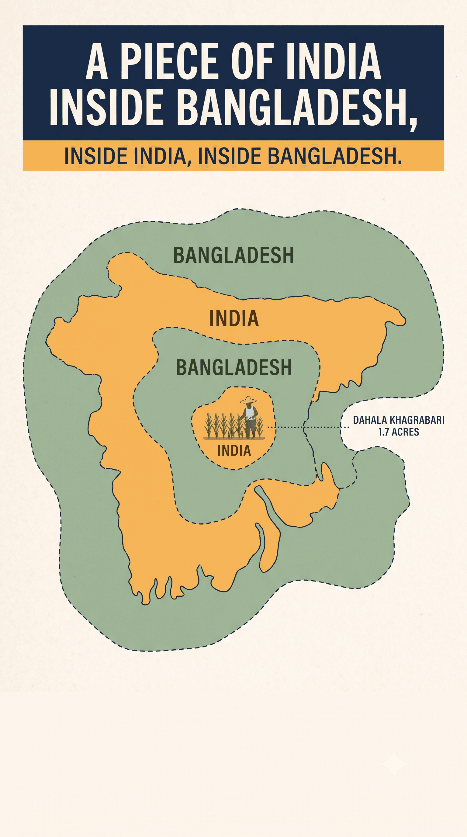
Not near India. In it. The field was Indian sovereign territory. It sat inside a Bangladeshi enclave, which sat inside an Indian enclave, which sat inside Bangladesh. Four territories, nested, in a space you could cross on foot in minutes. To walk there from the Bangladeshi mainland, you crossed an international boundary three times.
Its name was Dahala Khagrabari, in Debiganj, Panchagarh district, and until 2015 it was the only third-order enclave on Earth.
How you end up with a field inside three countries
The story people like is that it was gambling debt — that the Raja of Koch Bihar and his counterpart in Rangpur wagered villages against each other over cards or chess, and the borders are the scorecard.
It is a wonderful story and historians treat it as folklore. One scholarly account calls the chess version "fantastic" and probably misleading. The legend is usually told with a "Maharaja of Rangpur," a title that did not exist; the Mughal official there was a faujdar.
The likelier explanation is duller and sadder. A series of peace treaties between the kingdom of Koch Bihar and the Mughal Empire, signed between about 1711 and 1713, ended a war without actually settling where the boundary ran. Villages held by one side or the other simply stayed held, scattered through each other's territory, and nobody tidied it up.
Nobody tidied it up for two hundred years.
One correction to the version you usually read: these were not lines drawn by Cyril Radcliffe at Partition. Radcliffe divided the British Indian province of Bengal. Cooch Behar was a princely state and was not his to divide. The enclave boundaries were the old Koch Bihar–Rangpur lines, already centuries old. What changed is that Rangpur went to Pakistan in August 1947, and Cooch Behar then merged with India under an agreement signed on 28 August 1949, taking effect at the start of 1950. At that moment a tangle of 18th-century landholdings quietly became a tangle of international boundaries. Border controls followed in 1950, passports and visas in 1952.
The 1713 muddle became permanent the moment it acquired passports.
Counting them is harder than it sounds
You will see several different totals, and they are not all errors — they count different things.
By land parcel, the geographer Brendan Whyte's survey gives 102 Indian enclaves in Bangladesh and 71 Bangladeshi enclaves in India, plus 21 Bangladeshi counter-enclaves, 3 Indian counter-enclaves, and Dahala Khagrabari: 198 pieces of ground in total. Other scholars give 197, 192 or 225.
By administrative unit — the mauza, a revenue division — the two governments agreed a different figure at a 1996 border conference and used it for the exchange: 111 Indian and 51 Bangladeshi, 162 units. There is no one-to-one relationship between a parcel and a mauza, which is why both sets of numbers are correct and neither converts to the other.
So: 198 pieces of land, exchanged as 162 administrative units. When you read "162 enclaves," that is the diplomatic count, not the geographic one.
What it is like to live in a place like that
A joint India–Bangladesh headcount, conducted over four days in July 2011, counted 51,549 residents: 37,334 in the Indian enclaves inside Bangladesh, and 14,215 in the Bangladeshi enclaves inside India.
Treat that number carefully. The Joint Boundary Working Group elsewhere recorded 51,590. A later joint survey in 2015 gave 53,384. The enclave residents' own coordination committee rejected the official count altogether and claimed the true figure was several times higher. There had been no census inside the enclaves since 1951, and in 1995 an Indian minister told parliament the government had no dependable data on their population at all.
Note also where these people were. Roughly 72% of them were in Bangladesh, in Panchagarh, Nilphamari, Lalmonirhat and Kurigram. Only the 14,215 were on the Indian side, in Cooch Behar and Jalpaiguri. This is often written about as a Cooch Behar story; most of the people in it did not live there.
Here is the trap. Your village is legally Indian. It is surrounded in every direction by Bangladesh. India cannot reach you — to send a teacher, a doctor, a policeman or a ballot box, Indian officials would have to cross Bangladeshi territory, which they had no right to do. Bangladesh can reach you trivially, but you are a foreigner on foreign soil, and it has no jurisdiction to give you anything.
So you got nothing, in most of the enclaves, most of the time. No school. No clinic. No police station — which meant no recourse when someone took your land or hurt your family. No vote in either country.
Residents acquired what researchers call proxy citizenship: papers from the surrounding country, obtained irregularly, used to access ordinary life. Bashir Mia, a resident who spoke to reporters in 2015, put the schooling consequence plainly: "Our children will no more need to hide their identity to go to schools."
That is the quiet cost of statelessness. Not dramatic persecution — a lifetime of small forgeries required to do normal things.
It was not peaceful, and we should not pretend it was
It is tempting to write this as a bloodless administrative curiosity that was eventually tidied up. That is not what the record shows.
Residents were driven out of enclaves by mobs — one documented case in 1955, and accounts of people fleeing life-threatening violence around 1950. In May 2000, a crowd entered the South Moshaldanga enclave and looted houses; a week later attackers set fire to fifty-five houses, wounded ten people and abducted four. There was fighting around Dahagram–Angarpota during the 1965 war with casualties on both sides, and that war is what severed much of the enclaves' remaining access.
The Tin Bigha corridor — a strip India leased to give Bangladesh access to its largest exclave — was fought over for a decade. Three protesters died opposing it: Sudhir Rai in 1981, and Khiten Adhikari and Jiten Rai in 1992. It opened on 26 June 1992 under sustained agitation.
And the absence of policing had exactly the consequence you would expect. Al Jazeera reported in October 2015 that with no police presence for nearly seventy years, murders and other serious crimes in the enclaves routinely went unresolved. More than 75% of residents of Bangladeshi enclaves in India had at some point been imprisoned for entering Indian territory without valid documents.
The honest formulation is narrower than "it was peaceful": no interstate war was fought over the enclaves, and no state organised an expulsion. Everything else — arson, abduction, displacement, deaths in the corridor protests, and decades of ordinary crime with no recourse — happened.
Forty-one years between the fix and the fixing
India and Bangladesh signed a Land Boundary Agreement to resolve all of this on 16 May 1974.
It then sat unimplemented for forty-one years. The obstacle on the Indian side was constitutional: ceding territory required a constitutional amendment, and no government wanted to be the one that gave land away.
The amendment finally received presidential assent on 28 May 2015 as the Constitution (One Hundredth Amendment) Act. Instruments of ratification were exchanged in Dhaka on 6 June 2015. The enclaves were exchanged at midnight on 31 July 2015.
India transferred 111 units and received 51 — a net loss of roughly 40 square kilometres. Dahala Khagrabari went to Bangladesh, and the world's only third-order enclave ceased to exist.
Residents could choose: stay and take the citizenship of the country now surrounding them, or move. All 14,863 residents of the former Bangladeshi enclaves became Indian citizens; 37,532 residents of the former Indian enclaves became Bangladeshi. Nobody in a Bangladeshi enclave chose Bangladesh.
Around 979 people opted to leave their homes and relocate to India. By the end of November 2015, 920 had actually gone, and 61 had changed their minds and stayed.
On the night itself, people on both sides lit candles and torches and stood outside. Bashir Mia, 46, told reporters: "We are free now, we are Bangladeshis." Another villager told Reuters: "I forget all sadness today by lighting this torch of happiness."
The part that is easy to miss
The following May, West Bengal went to the polls. In the former enclaves of Cooch Behar, 9,776 people were newly registered to vote; about 85% of them turned out on 5 May 2016.
Tahalu Raiburman was 65. Officials had run a training session with a mock polling booth, because he had never been inside one. He told the Los Angeles Times: "I feel I am worth something."
That sentence is the whole story. Not the maps, not the nesting, not the 1713 treaties. A man reached retirement age before any state would confirm he existed, and what changed it was two governments finally agreeing to move a line on paper.
It also makes a point worth sitting with. Borders get discussed as though they are about security, or resources, or identity. For the people in these pockets, a border was simply the difference between having a school and not having one.
The resolution is genuinely good news, which is rare enough in this subject — but it was not tidy, and it was not quick. The fix was agreed in 1974 and delivered in 2015. In between, people were burned out of their houses, three died protesting a corridor, and two generations grew up without the ordinary paperwork of being a person.
Fifty thousand of them went to bed as nobody and woke up as citizens. It took forty-one years longer than it should have.